

Found in Craig County, Virginia to West Virginia, this is a challenging trail for serious rigs. It’s a fun trail that requires some serious skillsets.
Potts Mountain West Trail, distinct from the Potts Mountain Jeep Trail, is an off-road route located in Craig County, Virginia, within the George Washington and Jefferson National Forests. This trail offers a moderately challenging experience for off-road enthusiasts, featuring diverse terrains and scenic views.
Most stock rigs with modifications can handle this trail although we recommend rigs with at least a 2″ lift or more and 33″ tires.
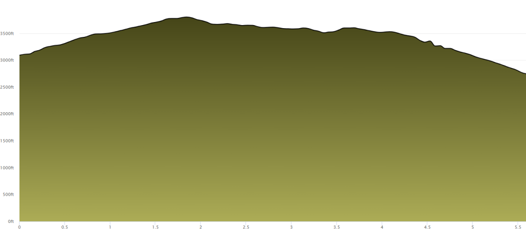
Length: Approximately 14.2 miles
Elevation Gain: Around 2,000 feet
Route Type: Point-to-point
Difficulty: Moderately challenging
While Virginia Off Road doesn’t specify exact trailhead access roads, the closest logical trailhead access would likely mirror the general approaches to Potts Mountain—via Route 311 toward the ridge area. Here’s a plausible route based on that:
Exit I-81 at Exit 141 for SR 419 (Electric Road).
Take SR 419 north, then turn right onto SR 311 North.
Continue north on SR 311 toward the Potts Mountain area in Craig County.
As you approach the ridge area, look for a suitable forest road or designated access point that would lead to the Potts West Trail—this might involve an unsigned or unpaved connector similar to the trail’s layout on ridgelines. (Public maps like onX Offroad or GPS devices may help reveal these connectors.)
Once on the trail’s access road, you’ll travel ridgeward to reach the western trailhead—considered the starting point for traveling eastbound along the Potts West Trail.
Trail Characteristics:
The Potts Mountain West Trail traverses a variety of terrains, including forested areas and open ridgelines, providing scenic views of the surrounding landscape. The trail features steep, rutted, and rocky conditions along a narrow path, requiring vehicles with high-clearance suspension and all-terrain tires.
Preparation and Safety:
- Vehicle Requirements: A high-clearance, four-wheel-drive vehicle equipped with all-terrain tires is recommended.
- Skill Level: Suitable for drivers with moderate off-roading experience.
- Weather Considerations: Check local weather forecasts before your trip, as trail conditions can become more challenging after rainfall.
- Navigation: Carry a detailed map or GPS device, as cell service may be unreliable in this remote area.
- Permits and Regulations: Ensure compliance with local regulations and obtain any necessary permits before embarking on the trail.
For a visual overview of the trail, you might find the following video helpful:
Want to contribute to this page?
If you have images, information or insights to this trail, email us and let us know. We will update the page with your media or information, even if you are not a member.
No responses yet